
Revised 28 January 2022
Accepted 25 November 2022
Available Online 10 January 2023
- DOI
- https://doi.org/10.55060/s.atssh.221230.001
- Keywords
- Third expedition of James Cook
Petropavlovsk-Kamchatsky
General plan of the territory
City development
Typology of buildings - Abstract
This article concerns the territorial location and development of Petropavlovsk-Kamchatsky, established by 1779. The study of this issue is based on the graphic and textual materials of the Third Expedition of James Cook. The purely documentary nature of the plans and drawings allowed the author to recreate one of the initial stages of the city's existence.
- Copyright
- © 2022 The Authors. Published by Athena International Publishing B.V.
- Open Access
- This is an open access article distributed under the CC BY-NC 4.0 license (https://creativecommons.org/licenses/by-nc/4.0/).
1. INTRODUCTION
It should be emphasized that up to now the topic we have chosen has not attracted the attention of researchers and, accordingly, the illustrative material we have involved has not been published in the specialized literature. Russian settlements appeared in Kamchatka, which was annexed to Russia in 1697, due to the Russian Cossacks who found themselves here in the middle of the 17th century. However, Petropavlovsk itself arose almost a century later, when the nearby ostrogs founded by them (Bolsheretsky, Tigilsky, Verkhne-Kamchatsky and Nizhne-Kamchatsky) still continued to exist [1]. Undoubtedly, even before that, residential and economic buildings of the Itelmen family Toyona Niaki were already located along the shores of its sandy spit. As another ostrog, the first “Russian” buildings near Petropavlovsk appeared on the northern shore of the Niakina harbor, near the Kamchadal village of Aushina in the summer and autumn period of 1740. At the same time, a very small soldier's team under the leadership of Captain V. Bering, who happened to be here, cut down on the shore “servants' living quarters and stocks for storing provisions and store materials”. He, in honor of the saints whose names were borne by the ships of his expedition, named Niakin's cove the harbor of the Holy Apostles Peter and Paul, and the expedition settlement built under the guidance of navigator Ivan Elagin soon became known as “Peter and Paul Harbor” or “Peter and Paul Port”.
Leaving Kamchatka with his ship's crew in the summer of 1743, Bering left a small garrison on the shore of the Avacha Bay to guard the newly built buildings. S. Krasheninnikov, who was in Kamchatka until June 1741, will note in this regard: “Officers' quarters, barracks, stocks and other buildings from the naval team were built at this bay. There, after my departure, a new Russian ostrog was established, to which residents were transferred from other ostrogs. (...) Kamchatka housing near the guba has two ostrogs – Aushin and Tarein: the first on the northern side of it near the Russian settlement, and the other on the south-western side, according to which the mentioned guba is called Tareina; both are a mile or so from the mouth” [2]. He also emphasized that when he visited Aushin ostrog on 16 March 1740, he did not find anyone: “the inhabitants of that ostrog dispersed from hunger”, and he will report about Tarein ostrog that “there are 2 yurts in it, 30 booths” [2].
Even a century later, in the middle of the 19th century, Petropavlovsk was a large village with houses scattered in disorder on the shore of a Small Bay (Bucket). Describing this settlement in 1851, the geologist and traveler Karl von Ditmar emphasized: “Between the bay and the lake are located, bordering streets and squares, almost exclusively state-owned houses, standing very spacious; the number of these houses, according to the governor's office, stretched to 40... This, the best-built state-owned part of the city is directly adjacent to the unofficial one, located along the entire eastern shore of the little bay and forming five elongated parallel with it rows... There are only 116 houses here. The whole of Petropavlovsk is built exclusively of wood, and all private houses are covered with reeds and long grass, while state-owned ones are covered with iron. At the very end of the bay, directly to the shore, there are buildings of the maritime department: a guardhouse, several stocks, a bakery and several small workshops...” [3].
In the book published four years later, in 1855, by V.K. Voit “Kamchatka and Its Inhabitants”, the author notes: “The city is built almost in a valley, on the gentle soles of two huge mountains, on the right Birch mountain, and on the left Nikolskaya mountain, in view of the ever-smoking Avacha knoll, at the very Peter and Paul Bay. It consists of about three hundred one-story wooden houses, since there are frequent earthquakes, a church almost in the middle, the house of the chief, and now the Governor of Kamchatka, on the right hill: a garden stretches from it along the slope, gardens are fenced around some houses, the entire space between the houses is overgrown with thick grass, paths stretch in different directions there is no riding in carriages; in places, near houses, mountain springs flow. In summer, this small town, rising from the greenery, presents a picturesque view surrounded by mountains, some of them covered with a solid color of wild roses, rhododendrons, honeysuckle and lilies” [4].
Finally, summing up the entire pre-revolutionary period of the development of Petropavlovsk, the researcher will emphasize: “Until the first decade of the twentieth century, the settlement on the shore of the Avacha Bay was a large village, although by that time it had been listed in the rank of Russian cities for almost ninety years (1822). Its border from the first buildings (1740) did not go beyond the Kultuchny Lake and the stream Gremuchy (G.I. Shchedrin Square). Houses built anywhere could not even form streets. Only next to the church, in the center of Petropavlovsk, to the left and to the right of it, the houses stood more or less on the same line, forming a street. They called it Bolshaya or Pervaya (Leninskaya). Parallel to it, higher up the slope of Petrovskaya Sopka, there was a second street, called the Second (Soviet). Along Nikolskaya Sopka there was Ozernaya Street (Krasintsev)” [5].
The population of Petropavlovsk, which varies greatly at different times, is very indicative. So, at the beginning of the 1740s, up to 200 people lived in it, at the end of the 18th century it was half as much, only 100, but in 1854 it was already 16 times more, 1600 people. The third expedition of the famous English navigator James Cook (1728–1779), which began in 1776, ended four years later, in October 1780. The safe return to their homeland of the crews of two research ships with very extensive research baggage (text and graphic) will be carried out already under the leadership of Captain D. Gore. Initially, both ships “Resolution” and “Discovery” will cross the Indian Ocean from west to east and in the first days of February 1778 rushed to the shores of North America, which they reached on March 7. Further, the route ran strictly north along the already unknown American coast to solve the fundamental task: the opening of the sea route from the Pacific to the Atlantic Ocean.
The British were in the Peter and Paul harbor on 29 April 1779, after the death of Cook. Having significantly replenished food supplies here, on 12 June they moved from here strictly north along the eastern coast of Kamchatka, but after passing the Bering Strait they will again run into impassable ice. Repeated attempts by Captain Ch. Clerk (1741–1779) still groped for at least the slightest possibility of further progress to the north would not lead to anything, and on 27 July he decided to return both ships to Petropavlovsk. This time the members of the expedition stayed here from 22 August to 8 October with the assistance of the “temporary commander of Kamchatka” Captain V.I. Shmalyov. Actually, then they created an extensive collection of materials illustrating both the geographical location of the bay itself and Petropavlovsk itself with the only Russian port on the edge of Asia.
Even during the preparation of the expedition, the British Admiralty and the Royal Society provided James Cook with a variety of text and graphic materials that were collected at that time. A special role in this regard was played by British diplomatic representatives accredited in Russia, who were closely interested in the latest Russian discoveries. Perhaps the most valuable for Cook and his team was the London edition of the book “The History of Kamchatka and the Kuril Islands” published in 1764, which clarified in detail the various features of this very vast region, about which reliable information was almost completely absent in Western Europe before that [6]. Moreover, the planned route to the northern part of the Pacific Ocean quite allowed, under all kinds of unforeseen circumstances, forced stops also in Petropavlovsk. This English illustrated book was based entirely on the two volume “Description of the Kamchatka Land” published in 1755 in St. Petersburg, created by Professor of Botany of the Academy of Sciences S.P. Krasheninnikov (1711–1755) shortly after his death. The engraving “Peter and Paul Harbor” was also placed here, which recorded its coastal development.
2. THE GENERAL TERRITORY OF PETROPAVLOVSK ON NEWLY CREATED MAPS
In the very intense four–year cartographic activity of James Cook's Third Expedition, Cook's “second assistant”, James King (1750–1784), who studied at Oxford, took an active part, he also left a detailed account of the stay of the British in Kamchatka. An important contribution to the cartography of Kamchatka was made by “captain and navigator” W. Bligh (William Bligh, 1754–1817). It is with him that the creation of the most accurate map of the entire Avacha Bay at that time with its immediate surroundings, which included the modern plan of Petropavlovsk, should be associated (Fig. 1). The drawing “Plan of the Harbour of St. Peter and St. Paul”, created on an enlarged scale, fixed its northeastern tip, marked by the inscription “Town of St. Peter and St. Paul” at the natural spit. As follows from this general plan, the urban area itself included the significantly lowered northern coastal foothills of the bay itself with a strongly extended sand spit that jutted into it at an acute angle. This spit, with its relatively small width, largely overlapped the northern tip of the bay, there was a very small water channel only on the western side. Just this territory at the end of the 18th century continued to preserve the main array of buildings in Petropavlovsk. On the same general plan in the northern tip of the bay we find the inscription “Hospital”, which clearly indicates the location of several wooden buildings associated with the activities of Russian settlers. Further to the north, there is a lake squeezed between the mountains under the current name of Kultuchnoye, the coastlines of which were not inhabited, and even to the north there was an ostrog with several wooden buildings.
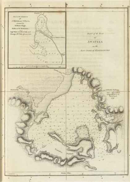
Plan of the Bay of Awatska on the East Coast of Kamtschatka. Plan of the Harbour of St. Peter and St. Paul, surveyed by William Bligh, master of the Resolution. In: J. Cook, J. King. Voyage to the Pacific Ocean. Undertaken, by the Command of His Majesty, for Making Discoveries in the Northern Hemisphere. Performed Under the Direction of Captains Cook, Clerke, and Gore, in His Majesty's Ships the Resolution and Discovery; in the Years 1776, 1777, 1778, 1779, and 1780. London: 1785.
3. PANORAMA OF PETROPAVLOVSK & FEATURES OF ITS DEVELOPMENT IN JOHN WEBBER'S SCHEDULE
The only “official artist” of the expedition was only John Webber (1752–1793). James Cook stressed that he was specially “hired to supplement his master drawings with written reports”.
The full-scale drawings made near the coast of Avacha Bay, including those made from the ship, also go back to Webber's work. Some of them will already illustrate one of the first English editions devoted entirely to Cook's Third Expedition as engravings [7]. On one of the panoramic views near the eastern coastline of Kamchatka and in the direction of Petropavlovsk, the artist will depict the barely protruding volume of the Lighthouse anchoring one of the most significant local hills at the intersection of the Pacific Ocean and Avacha Bay1 ([8], pp. 516).
In Petropavlovsk itself, the crews of Resolution and Discovery visited twice and stayed there for a long time, allowing Webber to perform a series of works illustrating, among other things, the characteristic features of its development. These graphic sheets actually confirm two descriptions of Petropavlovsk made by two crew members. So, at the end of April 1779, Lieutenant D. King will note in his diary: “The whole country is covered with ice, and it is difficult to imagine a more gloomy picture, we noticed several log houses and cone-shaped huts on poles, but their pathetic appearance and small number did not allow us to assume that this is the village of St. Peter and St. Paul. (...) Through the spyglasses, two people could be seen wandering around the huts” ([8], pp. 489–490).
And in Samwell's diary entry of 16 July of the same year, it was specified: “The village, or the ostrog of St. Peter and St. Pavla stands on a narrow sand spit that forms a harbor and separates it from Avacha Bay, and a narrow passage between rocks leads to this harbor. The village consists of five or six Russian log houses and about fifteen booths and three or four yurts. The booths have the shape of a cone on a wide base and are supported by pillars about four yards high. There are climb stairs made of thick beams, in which steps are embedded. The yurts are partially sunk into the ground and covered with earth. Previously, they were entered from above, but since the Russians settled here, doors are being made in yurts on the side. In this village, the yurts are completely abandoned, and the Kamchadals live in booths. In front of the booths there are platforms on which a lot of fish for dogs are dried, and fish for their own use hangs and dries under the booths. (...) At the upper end of the harbor of Peter and Paul is a barrack for soldiers and a warehouse, and these are the most” ([8], pp. 512–513).
Webber created his most impressive panoramic view under the general name “The City and the Bay of Petropavlovsk in Kamchatka” in late August – early September 1779, thereby capturing the main array of its buildings against the background of Avacha Bay (Fig. 2). Thus, he will show the entire sand spit, which included residential and outbuildings frontal from the north side.
As the artist records, at that time there were a total of twenty-nine wooden buildings of different sizes located on the spit. All of them were grouped asymmetrically along its entire very long territory from west to east, and were actually divided into three main types. The overwhelming number of them, twenty, were represented by the so-called “booths”. The very design of these relatively small summer dwellings, designed mainly for one family of Kamchadals, took into account the location of an extremely lightweight tent building on vertically installed logs. Accordingly, its connection with the earth was carried out by means of a wooden ladder. And eight one-story residential buildings, fully in line with the centuries-old tradition of Russian architecture, were located in the immediate vicinity of the booths. Despite their different dimensions, they were all made of logs and ended with two and four pitched roofs covered with straw. Their exclusively residential functional use is confirmed by the presence of the depicted furnaces with brick pipes through which smoke is visible.
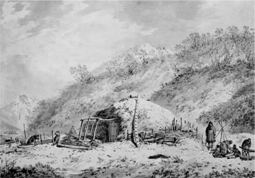
Only one winter dwelling of the Kamchadals is found in the westernmost part of the spit. On this side, it closed the entire linear building development of it. From the outside, this peculiar example of purely local traditional architecture was a geometrically outlined mound with a single upper hole in the middle. And Webber will fix the solution of his typical interior space on the neighboring island of Unalaska in mid-October 1778 [9].
The full-scale drawing confirmed that at first it was necessary to take out a lot of soil and open only one room with significant digging into the ground. From the inside it was sheathed with boards with extensive use of wooden beams, which provided the necessary strength. Above the surface of the earth, previously removed soil was poured in the form of a semicircle and represented a small symmetrical mound. This winter structure, created from improvised means alone, provided reliable protection of the Kamchadals from the cold even in the most severe frosts. They got into their “insulated underground granary” with the help of a long ladder through a round hole made in the same earthen “roof”, from there the smoke of the hearth flowed, which simultaneously served for cooking, lighting and heating the room itself. At the same time, the main element of the interior decoration of this kind of dwelling was the wide shelves located perimetrically along all four walls, which provided household members with daily leisure and overnight accommodation during a short winter day and a long night.
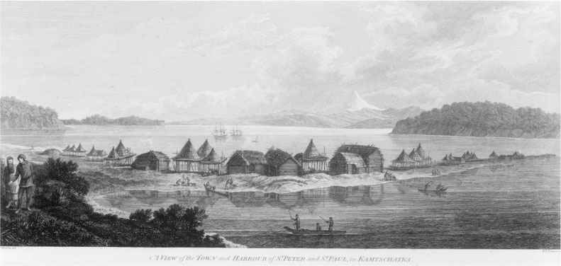
J. Webber del., B.T. Pouncy sc., “A View of the Town & Harbour of St. Peter and St. Paul in Kamtschatka” (National Library of Australia, Rex Nan Kivell Collection, NK1426).
In this regard, the description given by James Cook himself is very remarkable: “Dirt in native houses is inevitable if we take into account the way they are built. The natives dig an oblong pit in the ground to a depth of two feet, and sometimes less deep, its width and length are rarely more than 50 and 20 feet, respectively, but usually these pits are not made so large. A roof of driftwood is hung over this pit, and from above it is covered first with grass, and then with earth, so that it looks like a pile of manure. In the middle part of the roof, square holes are left: one for light, the other for entry and exit, and inside they go down by a ladder or, rather, along a post with notches that serve as steps. Some houses have holes at the bottom, but this is not quite usual. Separate rooms for each family are arranged along the sides and ends of the house, and people sleep and work there. There are no benches, but along the walls there is a trench dug in the ground and covered with mats, and this is the most worthy place in the dwelling. But the middle part of the house is open to everyone and looks very different, because although the floor is covered with dry grass, all the dirt is dumped here; it is also a place where they relieve themselves, and the stench of urine does not at all suppress the smell of raw hides and skins, which are constantly sour here. Behind the gutter and above it are stored the personal belongings of the natives – clothes, mats, skins, etc. (...) I have not seen any fires in any of the native houses. For lighting and heating, they use lamps that are very simple and perfectly meet these goals. Lamps are made of flat stones by drilling holes the size of a plate or a few more; oil is poured into this hole and dry grass is placed, which serves as a wick” ([8], pp. 390).
Already with more detail, Webber will fix the design of the Kamchadal buildings from the western side and all on the same spit in his watercolor drawing entitled “Summer and Winter Habitations in Kamtschatka” (Fig. 3). On this sheet, he depicted two Kamchadals – a girl and a boy – who are comfortably located on the elevated extended wooden platform of his summer dwelling. This platform, which was closely adjacent to the tent building, also rested on wooden supports placed vertically with a given rhythm. Another drawing by Webber illustrated the appearance of a Kamchadal residential building, designed for one family, located directly under the slope of the mountain with some digging into the ground. However, it most of all resembled a natural hillock rounded in plan due to the earth being poured on top (Fig. 4). Only on one side it was cut off for the doorway which, however, was used only in the warm season. When everything was covered with a thick layer of snow, the only living room was also entered by means of a ladder through a specially arranged upper hole. And near this building, the location of a very characteristic household yard for Petropavlovsk of those years with an indispensable hearth, which is shown without any fencing, is also shown. The interior of this dwelling was represented by a single room, reinforced on all sides with horizontal and vertical poles [10]. A very special design solution is marked by a wooden building, which was probably also located on a sand spit. This can be judged by the watercolor copy of “The method of drying fish at booths or summer dwellings in Petropavlovsk in Kamchatka”, taken from Webber's original work by an unknown London schedule in 1809 [11]. This economic structure under a gable roof simultaneously combines the features of Russian and Kamchadal buildings. So, the picture clearly shows that at that moment another bundle of hay is being placed in it. And on its wooden structural elements, in addition to fish, we notice skins and furs hanging everywhere for drying as the main object of exchange and sales of local residents.
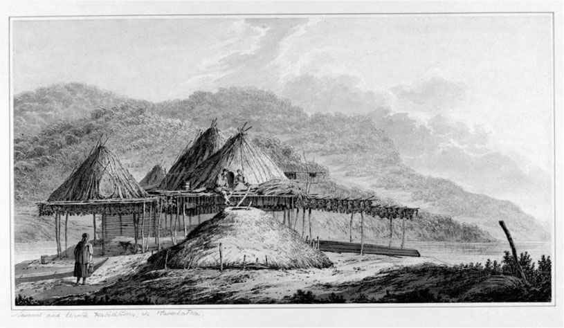
J. Webber, “Summer and Winter Habitations in Kamtschatka”, 1779 (State Library of New South Wales, Australia).
J. Webber, watercolor, “Family in Front of Hut Covered With Leaves, Kamtschatka Peninsula”, 1779 (State Library of New South Wales, Australia).
4. CHARACTERISTIC ELEMENTS OF THE PETROPAVLOVSK DEVELOPMENT IN WILLIAM ELLIS' SCHEDULE
During the Third Expedition, W. Ellis (William Wade Ellis, 1751–1785) was listed as an “assistant surgeon”, but his contemporaries primarily remembered him as a gifted draughtsman and watercolorist. The largest number of drawings made by him from nature was devoted to Kamchatka, while special attention will be paid to Petropavlovsk located close to the bay of St. Peter and St. Paul. The fixation of a number of its buildings at that time, including the buildings that settled here around the middle of the 18th century Russian settlers, should be associated with Ellis' drawings. So, dated 10 September 1779, his watercolor drawing entitled “View in Avacha Bay, Kamchatka” depicts its entire northern tip with a number of buildings near the coastal edge (Fig. 5). Actually, this territory of Petropavlovsk, which at the turn of the 19th–20th century will be already quite densely built up, at this time contained several similar wooden buildings of a purely Russian type under gable roofs. One of them was built right between two converging mountain slopes, corresponding to the main axis of the bay in the north-south direction. With more detail, Ellis demonstrated a residential house of Russian immigrants, which is very characteristic of the development of Petropavlovsk. Also created from nature, this watercolor drawing is known as “A Russian Hut, in the Harbor of St. Peter and St. Paul, in Kamchatka” (Fig. 6). This building, built right on the shore of the Peter and Paul Bay, but already clearly dilapidated from time, is a typical Russian log house under a four-pitched roof covered with straw alone. One of its facades shows a very small window, tightly shuttered. The outer walls themselves, to strengthen the construction, are supported by additional logs. On the roof we notice specially sketched poles to hold all the straw with such frequent squally winds here.
The panoramic drawing made by Ellis captured the mentioned spit with the main array of its linearly built buildings, which at that time formed the main array of buildings of the then Petropavlovsk [12].
Another panorama created by Ellis of the Bay of St. Peter and St. Paul is under the name “Winter in Kamchatka” on 8 October 1779, just before the departure of the Third Expedition to his homeland [13]. Ellis captured a completely snow-covered view of the vast coastal space at a considerable distance from the sand spit from the south-eastern side, thereby confirming the absence of any buildings of Petropavlovsk here. Therefore, it was here that the British set up their canvas tent, where their numerous barrels of food were stored.
5. CONCLUSION
It should be emphasized that in addition to the British, all other illustrative sources, one way or another confirming features of the location of Petropavlovsk and the very nature of its development at the end of the 18th century, are completely absent. Accordingly, there is still no historiography on this issue. The research material presented above is entirely based on detailed plans created by English specialists and drawings made directly from nature, including panoramic views. They made it possible to clarify the real picture of the arrangement of Petropavlovsk in 1779. Having studied in detail all this professionally executed documentary graphics, we were able to clarify a number of trends in the arrangement of Petropavlovsk in the specified time period.
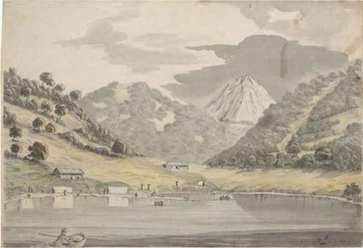
W. Ellis, watercolor, “View in Avacha Bay, Kamchatka”, 1779 (National Library of Australia, pic-an 2816823).
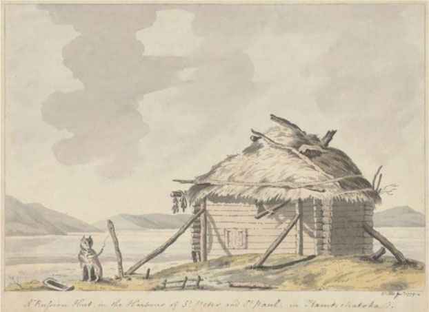
W. Ellis, watercolor, “A Russian Hut, in the Harbor of St. Peter and St. Paul, in Kamchatka” (National Library of Australia, pic-an 2816699).
ACKNOWLEDGMENTS
This study is based on research supported by the Program of Fundamental Research of the Russian Academy of Architecture and Construction Sciences and of the Ministry of Construction, Housing and Utilities of the Russian Federation, 2022.
Footnotes
REFERENCES
Cite This Article
TY  - CONF
AU  - Vladimir Chekmarev
PY  - 2023
DA  - 2023/01/10
TI  - Petropavlovsk-Kamchatsky in 1779 Based on the Materials of the Third Expedition of James Cook
BT  - Proceedings of the 4th International Conference on Architecture: Heritage, Traditions and Innovations (AHTI 2022)
PB  - Athena Publishing
SP  - 3
EP  - 10
SN  - 2949-8937
UR  - https://doi.org/10.55060/s.atssh.221230.001
DO  - https://doi.org/10.55060/s.atssh.221230.001
ID  - Chekmarev2023
ER  -


