Revised 25 January 2022
Accepted 21 November 2022
Available Online 10 January 2023
- DOI
- https://doi.org/10.55060/s.atssh.221230.018
- Keywords
- Hybrid spaces
Iconic environment
Green technologies
Macro-geoplasty
Macro-sculpture
Semiotic pair
Hybridization method - Abstract
This article attempts to analyze the possibilities of using the semantic language of modern ecological design in urban planning and architectural landscape projects based on a pair of semiotic signs “scale and image”. Their new interpretation for urban planning purposes is due to the rapid development of environmental technologies in urban planning, global climate change, urban densification associated with urban growth and population migration. Therefore, in projects with approaches in the engineering preparation of urban areas, they are interconnected with the surface collection, distribution and purification of rainwater, and at the same time, the use of macro-structures and macro-geoplastics sets a scientific search and a vector of development to create a memorable design of the urban environment through large-scale and figurative elements. Both directions create prospects and opportunities for the development of nature in the city on the basis of technologies that simulate natural processes, when the topic of “semantic images” acquires a new architectural and landscape meaning. In this regard, structures made of artificial relief can be made of different materials and can serve as protection from noise, wind and dust. This article presents options for such solutions.
- Copyright
- © 2022 The Authors. Published by Athena International Publishing B.V.
- Open Access
- This is an open access article distributed under the CC BY-NC 4.0 license (https://creativecommons.org/licenses/by-nc/4.0/).
1. INTRODUCTION
There is a need for a scientific search for the identity of each fragment of the urban environment with both technologies and design tools. In this regard, the use of architectural terms in terms of the transmission of iconic information in the urban environment and their subsequent execution for urban planning purposes can provide new opportunities for supported design and forecasting of urban development in this direction. The disclosure of the topic is supported by examples of the world practice of architectural and urban planning design, as well as the results of research in master's theses in the areas of “Urban Planning”, “Architecture” and “Landscape Architecture”, which focus the attention of specialists on an eco-oriented approach and technological progress in the field of iconic information transmission [1,2]. Creative search will allow to substantiate the features of integration of green technologies through the interaction of iconic architectural symbols, for example, scale and image, with different types of green technologies in modern design solutions in order to manage urbanization processes, climate risks and, most importantly, the development of identical and sustainable green territories of different scenarios of population activity. To master the topic of “iconic environment” and “technologies”, polar at first glance, it is of interest to determine the characteristics of each symbol and the means of transmitting such information from territory to object or from object to object as a tool for forming a new image of the environment around us based on technologies that simulate natural processes [3,4].
The issues of sustainable or supported development (the interpretation of the term still causes controversy among specialists) of urban areas in urban planning forecasting and design are particularly relevant at the present time. Renovation of urban development, new approaches to the reconstruction of historical centers of cities and historical sites, the development of former industrial territories, the arrangement of embankments, new transport, the integration of TPU and the preservation of the natural framework of cities remain topical issues of urban policy and development of Russia at the present stage. However, users' requests for a new quality of life in the city are becoming more and more pronounced, which is associated at the present stage of development of our society, primarily with issues of urbanization management, reducing the risk of natural disasters and climate change, and, as a result, new challenges in urban planning and landscape solutions. In many ways, the involvement of specialists in the analysis of ongoing changes in world practice regarding the active use of new technologies in building design and landscape typology in the center, middle and periphery of cities will influence the understanding and understanding of the role of natural components in the sustainable development of urbanized areas and the creation of a comfortable environment for living in a rapidly changing climate. For example, the countries of Europe and Scandinavia (the latter are especially close to Russia in terms of climatic conditions), at the turn of the late 20th and early 21st centuries, following the concept of sustainable development, went through the stages of restructuring urban areas in order to find a reserve of plots, rethinking the role of green components and the introduction of technological solutions, primarily in in order to improve living standards and change environmental sustainability indicators [5]. At the same time solving the problems of creating a new socio-cultural scenario in different parts of the city, there was an active introduction of environmental design with a design approach, which contributed to the development of social and economic aspects in the process of modeling territories [6].
It is the theme of ecological design, conservation and replenishment of nature, the introduction of technologies not only of a “smart” house, but also of a “smart” landscape with new constructive and design solutions that has been the leitmotif through such landmark urban development projects as: the residential area of Orlekion in Zurich, Hammarby Siestad in Stockholm, Arabianranta in Helsinki, Boulogne Billancourt (Boulogne Billancourt) and Clichy Batignolles (Quartier des Clichy Batignolles, Park Martin Luther King) in Paris, the residential quarters of Berlin at the Potsdamer Platz station [7]. In them, approaches in the engineering preparation of urban areas are interconnected with the surface collection, distribution and purification of rainwater, and at the same time, the use of macro-structures and macro-geoplastics sets a scientific search and a vector of development to create a memorable design of the urban environment through large-scale and figurative elements. Both directions create prospects and opportunities for the development of nature in the city on the basis of technologies that simulate natural processes, when the topic of semantic images acquires a new architectural and landscape meaning. On the other hand, the pandemic regime has revealed a number of issues in which psychological comfort in the city and a variety of natural scenarios within walking distance from housing occupy a priority place. Social distances are another challenge to technological and design progress in our cities.
2. THE PERCEPTION OF BLINDNESS
All new opportunities for the development of urban planning science and practice are associated with the improvement of urban planning policy in the field of reconstruction of already established megacities in terms of designing new cities, as well as interaction with the world urban planning community on climate change and management of urban development in the context of global urbanization [8,9,10]. Therefore, the creation of an artificial world of “second nature” around us within the framework of modern ideas and the needs of society forces specialists to largely reconsider the usual views on the theory and practice of architectural and urban planning creativity using technologies at the level of engineering preparation of the territory, landscaping, environmental design, work with the earth and modern macro-sculpture in terms of large-scale and figurative objects of new development of both world and our Russian cities. It will focus on the use of technologies to maintain the symbols and signs of the object that can affect the identity of each fragment of the urban environment, and the stability of both the architectural object and the city site as a whole. It should be noted that at the present stage of the development of science and practice of urban planning, architectural and landscape design, it is very important to search for new forms and tools both to improve the aesthetics of the object and the environment in its surroundings, and environmental indicators of the place due to the transformation of the shell of buildings, landscape typology and new sculptural forms. In this work, it is progressively necessary to reveal the relationship and mutual influence of such polar, at first glance, directions of architectural creativity and urban planning design as a semiotic image in the nomination “iconic memorability of the environment” on a large scale, as well as issues of improving technologies, for example, rainwater harvesting, simulating natural processes and supporting new images and objects, and Wednesday. So, we can make the first assumption about the possibilities of engineering preparation of the territory in terms of working with the surface runoff of rainwater and its subsequent use in order to maintain nature in different parts of the urban area, especially in a limited area where a macro-structure can be used as a modern sculpture on a large scale and figuratively. According to semiotic characteristics, this means conveys figurative features and can be directly related to the history of the place (the spirit of the place), identifying a section of urban space. Here, the familiarity and memorability of the Image works on the individuality and identity of the environment, as well as on the detailing of the socio-cultural scenario of the place.
Another option for studying technologies for urban planning purposes is the disposal of construction debris and its use for the formation of large-volume geoplastics (macro-geoplastics) to change the visual characteristics of the territory with monotonous relief and the formation of green screens with protection from noise and wind. Moreover, macro-geoplastics can be used in different climatic conditions and serve as a place identifier. According to the same semiotic characteristics, this tool is associated with the scale of the structure, an ecological approach in the design of green objects of great height and extent, where the theme of scale with figurative additions dominates. Analyzing the design direction of working with a tablet, it is the topic of artificial relief that is given much attention. In the book of V.A. Nefedov “Urban Landscape Design” geoplasty is one of the main means of spatial change of the urban environment in various forms: from ellipses on the surface, where the Crimean Embankment project in Moscow can serve as an example, to geometrized geoplasty, one of the modern forms of organization of urban space in a memorable design.
It is safe to say both solutions are inextricably linked in architecture with the concept of scale and image, and technological solutions could contribute to urban planning, architectural and landscape content of this semiotic pair, which really represents the theoretical hypothesis and the basis of the study in this article.
Therefore, on the one hand, urban planning modeling includes an understanding of the main approaches, methods and concepts, according to the characteristics of which it is possible to determine the typological structure of an object or its typological image. Using the examples of world practice in projects of the 20th–21st century, it is possible to successfully trace and compare the evolution of the authors' ideas about the forms and carriers of this information. On the other hand, green technologies simulate natural processes and are an additional tool for urban planning, forecasting and environmental sustainability of an object with different typologies of buildings and landscape [11,12]. All this can have an impact on maintaining the chosen semiotic image and serve the purposes of urbanization management. Specialists traditionally use utilitarian means and features of the typological structure of buildings or landscape as the “language of modern design” to achieve greater aesthetic expressiveness of design.
The first ones include: the surface of the earth, the design of relief forms and vegetation, water bodies and, of course, the design interpretation of modern sculpture. In this article, we are interested in the means that can be used in integration with technological solutions, contributing to the sustainable development of both individual sections of the city and its natural territories with the framework of the city as a whole. Therefore, it is the forms of artificial relief and modern sculpture in the macro-volume nomination that can have a significant impact on the formation of the concept of “technological” Scale and the Image of modern architectural and landscape objects and urban planning solutions in the central part of cities with a shortage of non-architectural space, as well as in the middle and on the periphery of the city, where there is a reserve of territories. In each case, based on technological solutions, new opportunities for using scale and image in urban planning projects with their new “reading” in the light of the concept of sustainable development appear.
It should be noted that such “reading” of figurative information from an object in order to objectively assess a semiotic feature, for example: scale or image as an architectural feature, and filling it with certain typological features allows using these data in the design of urban development facilities, using new approaches in the engineering preparation of the territory, especially in the “sole” of large hills. For example, the rejection of the complete discharge of rainwater into storm water networks in favor of surface accumulation, movement, redistribution of this water and, as a result, the maintenance of green infrastructure from the position of sustainable (supported) development. If we focus on the prospect of developing and implementing such urban planning solutions, then the scientific scope of this topic is also expanding in the context of macro-geoplastics, which is directly related to the semiotic topic scale. New forms of modern sculpture are integrated into the theme of the image on a large scale, as art objects of the “spirit” of the time. Without their figurative interpretation, it is impossible, in my opinion, to create a memorable object with many technological solutions in its shell. For a deeper understanding of the stages of development and use of the semiotic pair scale and image and the connection of each sign with different types of technologies that simulate natural processes, it is necessary to turn to the history of the issue, analyze the landmark projects of the direction and evaluate new opportunities in choosing solutions on the way of megacities to sustainable development due to technological progress and figurative identity in the 21st century.
3. TECHNICAL ASPECTS
Projects such as the “Garden of Cosmic Speculation” (2007) by Charles Jencks and “Glass Bubble” (2006) by Monika Gora combine figurative identity, the scale of visual perception and the organic connection of each object with the landscape both in the interior and exterior of the building. The theme of image and technology runs through all the projects presented above. The huge geoplastics in the Charles Jencks project is, on the one hand, an example of large-scale work with land in the Land Art nomination, and on the other hand, an excellent design option on a site without relief, when issues of new zoning of the territory, problems of wind protection and planting sites of vegetation of different tiers (trees, shrubs) are solved due to artificial forms, cereals, etc.), as a compensatory gardening [13,14,15]. In a limited area, an integrated approach is needed to create a full-fledged environment of the object, in which a new socio-cultural scenario is based on technological solutions for integrating plant components both into the shell of the building and at different relief marks (Fig. 1). In the Jencks project, macroforms of artificial relief and sustainable vegetation of different types give the object signs of identity.
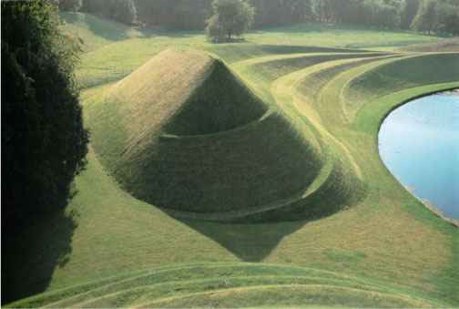
“Garden of Cosmic Speculation” by Charles Jencks (2007): a garden of cosmic installations, started in Scotland in 1989.
This is a project where the version of creating arrays of endemic vegetation on geoplastics (planting technology on slopes of different steepness) to the method of “imitation of a tropical forest” in an urban environment at an object in Sweden is vividly presented, as an example of the image of modern macro-sculpture. Technologies of integration of “artificial” plant forms into the natural landscape of a place based on the principles of ecological design are closely related to the world urban planning processes for the engineering preparation of the territory and landscaping. More than half a century of technology improvement in world architecture and urban planning illustrates the professional approach and ample opportunities for the renovation of sections of the city center and historical objects in the nomination “Scale and Image”. The appeal to macro-sculpture as an object in a sustainable environment makes it possible to realize new technology opportunities in different climatic zones, especially in the regions of the far north. Considering technologies from the point of view of improving environmental indicators and living conditions in the north, the example of a large-scale “Glass Bubble” (2006) by Monica Gora reveals the wide possibilities of greenhouses with winter gardens in the harsh northern climate (Fig. 2).
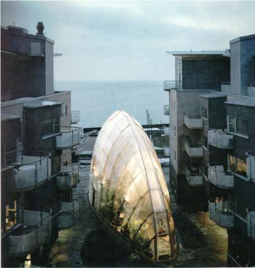
“Glass Bubble” by Monika Gora (2006).
Considering the difficult microclimate of hot summers, cold winters, salt-saturated winds and tall, shaded residential buildings, Monica Gora wisely and practically decided to create more favorable conditions for plant growth, with a structure that is an intriguing combination of garden, architecture and sculpture. The glass bubble is a protected modern construction made of glass and metal, which can be used all year round due to technological solutions with sustainable exotic plants from the tropics. The attractive curvy shape, similar to a bursting whale, creates a visually attractive macro sculpture and a pleasant combination with the geometric angularity of surrounding architecture. During long Swedish winter nights, the greenhouse acts as a welcoming beacon of light and warmth in the Nordic country, changing harsh conditions to a psychologically comfortable new socio-cultural scenario in the residential environment of the Vastra Hamnen district in the nomination “technological scale and image” through modern macro sculpture. The natural environment made it possible to gently integrate the assortment of plants by technological means, taking into account climatic conditions and urban planning methods at the level of architectural solutions and engineering preparation of the territory at all the objects under consideration. Being examples of ecological design by Scale (macro-geoplasty) and Image (macro-sculpture), the Jencks Garden and the Monica Gore Greenhouse are among the first projects to adapt technological solutions to new design conditions. The projects clearly demonstrate the option of returning natural nature to cities due to large forms of artificial relief, where geoplastics allows you to dispose of construction debris, get away from the monotony of the site and demonstrates the possibilities of technologies for the production of green elements with protective functions. These large-scale elements can be designed from different materials depending on the climatic conditions of the place and serve as examples of identical design. The example of a new generation winter garden takes on a new meaning in countries with harsh climatic conditions, when the design is both a modern macro-sculpture in the context of a city, and an aesthetic venture in a northern city, returning psychological comfort to residents in winter, and in a broader sense, a stable identical environment with a new socio-cultural scenario.
4. CLASSROOM MANAGEMENT STRATEGIES
The development of the theme of the iconic architectural environment and its maintenance by technological means is continued in the scientific search for master's theses in various areas, which is primarily related to the issues of protection from natural disasters (dust storms) and the influence of climate (northern territories), as well as issues of urbanization and restoration of nature in cities by various means. For professionals, the hybridization of typological characteristics between the technologies of preparing territories at the level of urban planning and forecasting, on the one hand, and semiotic signs in their large–scale and figurative interpretation, on the other, is of interest. In my opinion, there is a connection between the scale and the image of visual perception in the design of the environment with green technological solutions at the level of engineering preparation of the territory and landscaping in urban planning. To support the chosen topic in order to reveal its strategic and ecological potential for both urban planning and landscape design with its individual approach to each fragment of the urban environment, it is necessary to turn to scientific research through the relevant topics of master's theses. It is the areas of training in the master's degree that reveal the possibilities of a scientific approach and the methodology of modeling for a specific environmental situation with the formulation of a problem and ways to solve it. In [16] the problem of dust storms in Kazakhstan is considered. It is dust (sand) storms that, by their scale and frequency, can be attributed to a global natural disaster that causes serious environmental problems in the world. Dust storms are most often observed in arid areas (dry steppes, semi-deserts, deserts). On the territory of the Russian Federation, it is most often observed in the Astrakhan region, in the east of the Volgograd region and in Kalmykia. A large frequency of dust storms is observed in the territory of the Aral Sea and the Balkhash region (in southern Kazakhstan), on the shores of the Caspian Sea in western Kazakhstan, in Karakalpakstan and Turkmenistan. Mainly dangerous dust storms are considered to have a wind speed of 15–20 m/s. In Kazakhstan, during strong dust storms, the wind speed can reach 25–30 m/s.
Dust (sand) storms are a common phenomenon for the territory of Kazakhstan, as about a quarter of the territory of the republic is occupied by sandy deserts. The most dangerous and powerful source of air pollution by sand particles, for forty years, is the drained part of the bottom of the Aral Sea. The wind regime with increased speeds in combination with soils of light mechanical composition and sands contributed to the development of deflationary processes on the drained bottom of the sea and the removal of sand and salt aerosol to the surrounding areas [17]. The city of Kyzylorda is located in the south of Kazakhstan, located in a desert zone characterized by frequent and strong winds, mainly from the northeast direction. Severe destruction and blowing of soils poses a threat to human economic activity, causes enormous damage to many sectors of the national economy. The work of ground and air transport is disrupted and hindered, radio communication stops, reservoirs, irrigation systems are brought in, buildings are damaged, diseases increase [18]. Therefore, for people living in arid areas with arid climate and constant dust storms, it is very often necessary to take shelter from wind currents. Therefore, the creation of a new model of macro-construction in the landscape, integrating both artificial and natural materials in its structure, becomes an urgent need in areas with natural disasters in the form of dust storms. And volumetric elements collected from local rock with plantings of endemic vegetation can significantly change the scale and image of the place, corresponding to the natural risks and identity of the place. So, as a form of construction, it is proposed to use a bionic form, according to the design of a tablet resembling a rice grain, as an example of the use of local traditions in the field of agriculture and agriculture in the design of the urban environment (Table 1) [16].
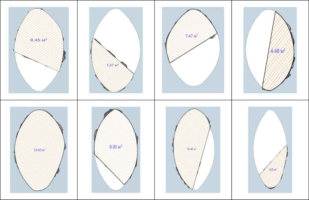
Such use of the surface pattern, in the form of grain, is due to the fact that the Kyzylorda region is in the first place in rice cultivation and its export to other cities and countries. The filling of the surface pattern can be different: by half, one third, segments, parts, and by alternating natural and artificial materials, you can achieve the maximum effect from using the form in volume (Table 2). Before us is a vivid variant of using the theme scale and image: a semantic pair in which the possibility of using local materials is presented, which supports the direction of environmental design and, together with the plants of the local flora, is a wonderful tandem of individual design and memorable design of the environment. The dimensions of the macro-structure and the height are very different: from small, medium to large sizes. It depends on the location of the structure in the city and with the reserve of the city territory. The proposed macro-structure will be multi-level, where local low-growing plants and shrubs will be planted at different levels, which also serve as a natural shield for catching and fixing sand, as well as for aesthetic and sun protection purposes in different seasons [16].
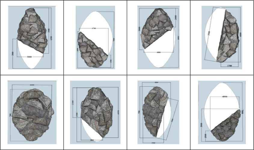
The approximate dimensions are shown in Table 3, and Table 4 and Table 5 show three variants of the macro-construction of local stone, depending on the size, surface area and height.
Also, depending on the size of the area covered with masonry (Table 4) it is proposed to distinguish 3 main designs: macro, midi, and mini.
Having a multi-level system, the maximum height of the largest structures will be 5m, medium will be 4m, and small 3m and/or 2m. The structure can be made of a flat natural stone (mineral) mined in the Kyzylorda region in the urban-type settlement of Zhanakorgan [16].
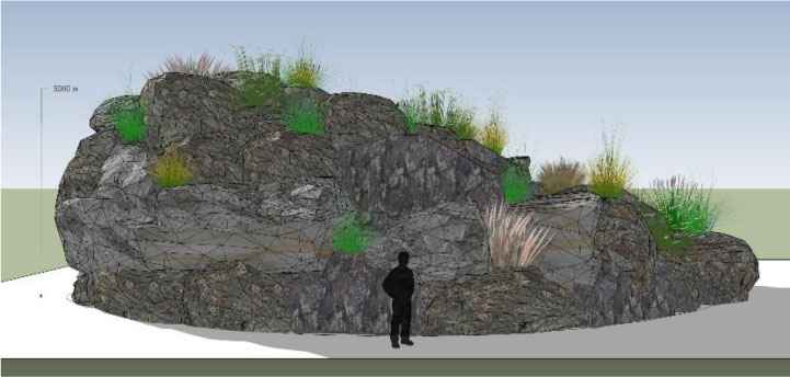
Natural stone for the use of construction: gabbro of Tashkent of various fractions and others. In order to more visually assess the scale of the structure, it is necessary to compare it with the size of a person. Fig. 3 shows that the proposed construction model is large-scale to a person when every citizen becomes protected behind its walls.
The use of natural stone, such as Tashikurai gabbro of various fractions and shades, as well as planting of local plants helps us achieve the most desired result.
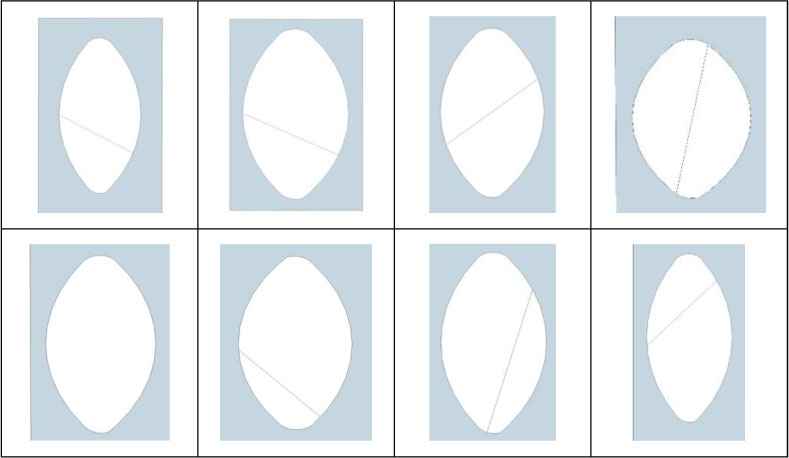
Earth surface design options.
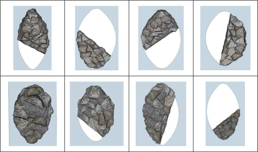
Options for filling the form with stone blocks.
Dimensions of the protective macro-structure.
| Design Size | Surface Area (m2) | Height (mm) |
|---|---|---|
| Macro | ≈ 22 | 5000 |
| Midi | ≈ 9 | 4000 |
| Mini | ≈ 4.5 | 2000 – 3000 |
The main types of construction depending on the size.
Area of masonry covering.
The scale of the protective macro-structure in urban space [16].

Macro-structure in urban space: the structure protects from direct sunlight during high-temperature seasons [16].
Fig. 4 shows the main viewpoints of the structure. It is shown that the proposed structure is stable, planted with local plants, and also creates shade, which is very good in a hot dry climate.
In the main list of plant assortment, local plants are used to form a macro-structure: multi-flowered comb (gingil) – Tamarix ramosissima, leafless Juzgun (candym) – Calligonum aphyllum, tree-shaped solyanka, white boyalych – Salsola arbuscula, Solanchak's hedgehog – Anabasis salsa, Sandy wormwood – Artemisia arenaria, Sandy grass – Stipa pennata subsp. Sabulosa, Swollen sedge – Carex physodes, Mortuk – Eremopyrum.
Summing up the results of the integration of technologies for the construction of a macro-structure of wind protection from local stone with plants of endemic flora, a layout scheme of the components of the macro-structure was performed (Fig. 5).
The city of Kyzylorda, located on the right bank in the middle reaches of the Syrdarya River, has a linear structure. Such a structure is usually found in cities located on sections of the coastal strip of seas, large rivers, mountain valleys, etc. The approved master plan for the development of the city of Kyzylorda shows the linear structure of the city, with the development of the left bank of the Syrdarya River as well. The master plan covers all the spectra of urban planning, which is based on the development of free territories in the northern and eastern directions. The compositional solution of the city's public center is based on the formation of a system of squares flowing into one another. The most important square of the city, where mass events take place, is the square in front of the akimat, which turns into the theater square. Much attention is paid to development of the recreational zone and improvement of the floodplain of the Syrdarya River. Considering the importance of the river as the main dominant influencing the formation of the appearance of the city, it is planned to arrange the embankment of the Syrdarya River as a linear element of the urban structure.
The existing functional zoning of the territory will remain and will be further developed in the system of public centers, the organization of green spaces, the formation of an optimal transport scheme in the city. In the industrial zones of the city, it is planned to streamline the territories for the placement of environmentally friendly industries. The typology and restructuring of the urban area are carried out for the purpose of research on the projected area, analysis of its empty or abandoned territories in order to locate the proposed macro-structures. In the course of the study, it was possible to determine that in the structure of the city, the macro-structure can be located linearly and locally in the system of “green corridors”, as well as in the main directions of the impact of dust storms on the city. The linear location can be represented as green corridors in the northern and northeastern part of the city as shown in Fig. 6, and the local location is in the city in a certain place, it can be, for example, a city square or central park, etc.
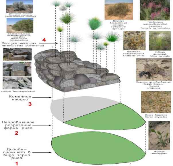
The scheme of superposition of the components of the macro-structure [16].
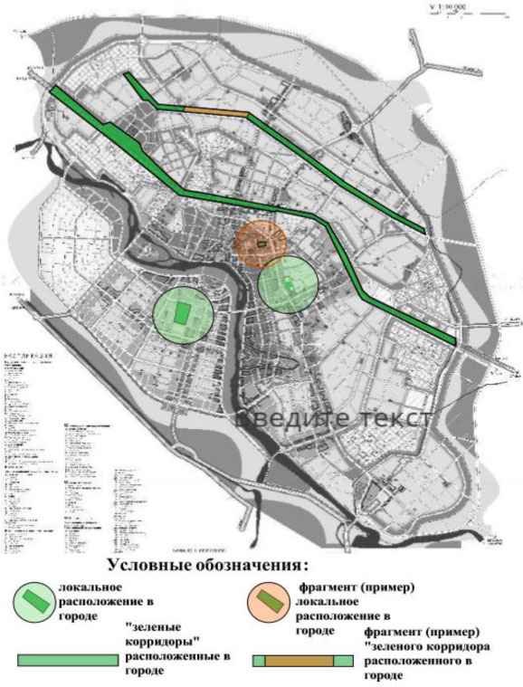
Location of the structure in the north and northeast of the city [16].
In the selected corridor in the north and northeast of the city, the tablet is supposed to be designed in the form of two active and modern lines: broken and wavy, with further superimposition of macro-structures in the form of rice grains with an emphasis on the prevailing wind direction in order to achieve results both in terms of protection from dust storms, and in the aesthetics of the design of the environment on the theme “Scale and Image” through geoplasty in the form of masonry from local stone.
The polyline is shown in Fig. 7 in red. It creates a beautiful pattern on the surface of the earth, thereby dividing the shape of the rice grain on the plane into parts. Wind flows that arise from the northeast side of the city are also shown, and how these dust flows are reduced and dispersed by the proposed design.
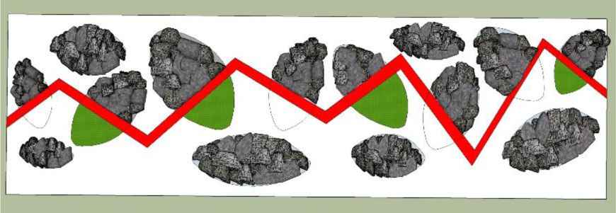
Diagram of polyline drawing in combination with the shapes and location of the macro-structure in the plan [16].
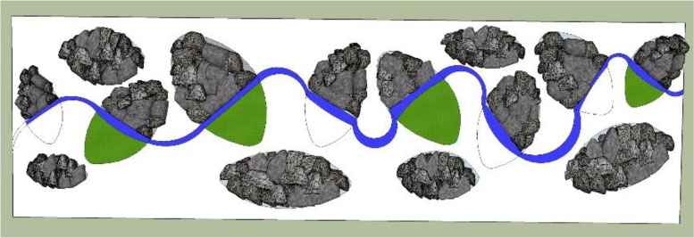
The “wave” line divides the proposed shape into components made of different materials [16].
Fig. 8 shows a diagram of a corridor with a wave-like pattern in the northeast of the city using a wave and ellipse in the design of the earth's surface, as variant of an identical design on the theme of scale and image, as well as ecological design as part of a new socio-cultural scenario in a fragment of urban space.
Fig. 9 shows an example of a scheme for the local arrangement of a macro-structure located in a city structure or in different parts of it. Fig. 10, Fig. 11 and Fig. 12 show a fragment of the territory of the city corridor with a pattern in the style of “Wave”.
The use of various styles of drawing the earth's surface improves and modernizes the situation in the city, as the forms are arranged in such a way as to dissipate wind and dust loads. Such corridors in the city can serve as a protective screen and catch the flows of dust storms, they are also used as “traps” of these natural phenomena (Fig. 13).
Fig. 14 and Fig. 15 show a fragment of the territory of the city corridor with a pattern in the style of “Wave”. It should also be noted that the text of the master's thesis contains forms and calculations for wind load in the city, as well as data on the stability of these stone forms of artificial relief and their effectiveness in protecting against wind, sand and sun.
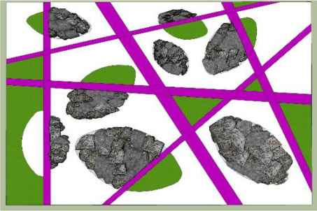
Local arrangement of a protective macro-structure made of stone in the city [16].
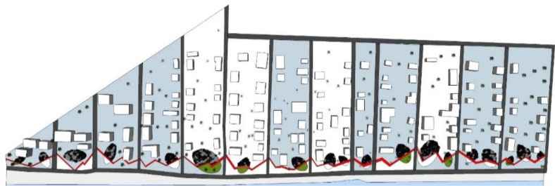
The “polyline” style and macro-construction in reading the topic scale and image by environmental means [16].

View of a fragment of a corridor with a drawing in the style of a “broken line” [16].

Visualization of scale and image theme through a polyline and macro design that protects against dust storms [16].
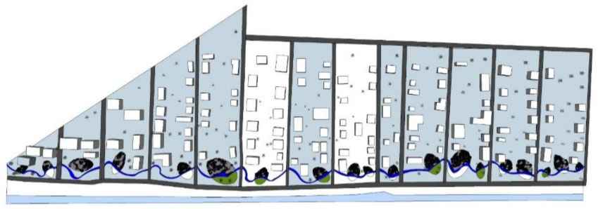
Model of the territory with the arrangement of the macro-structure in the style of “Wave” [16].

View of a fragment of the territory in the style of “Wave” [16].

Visualization of the scale and image theme through an undulating line and a macro-structure that protects against dust storms [16].
A macro-structure made of natural material in an urban environment will look modern when using a line in the style of “Broken”, “Wave” or “Intersecting” lines. The proposed design is also universal in that it not only protects from dust storms, but also creates shade, which is relevant in hot climates. The main aspects of macro-design design are the main aspects of the concept of sustainable development: ecological, social, economic and aesthetic. The ecological aspect is the use of local natural materials, as well as plants of endemic flora. The social aspect is revealed by the fact that macro-design solves the social needs of the population, and creates favorable conditions for being in the city and in different seasons. The economic aspect is that using local natural materials reduces the cost of building such facilities several times in a city prone to natural disasters in the form of dust storms. The aesthetic aspect supports in the macro-design the individuality of the design of the environment and the natural situation in the city by planting local beautiful flowering plants that are stable in these climatic conditions. In the new challenges of the 21st century, one more aspect should be highlighted, which is becoming more and more independent, since technological breakthroughs in the search for modern materials and design solutions are associated with it – this is, of course, the technological aspect. It supports technologies for collecting, redistributing, moving and preserving the volume of rainwater to maintain the created landscape of “second nature” at the facilities.
5. CONCLUSION
To conclude, it should be noted that the considered topic of scale and image is associated with new green design technologies in urban planning, architectural and landscape projects. Also, by the example of architectural and landscape objects of the 20th–21st century, their compositional morphology is dominated by a pair of semantic images – Scale and Image – each of which by technological and aesthetic means can support the development of the theme of each sign and serve the goals of the sustainable return of natural components to the architecture of buildings and the urban landscape. Using Kazakhstan as the example, with the problem of dust storms, the possibilities of macro-construction to convey the scale and image theme in areas of different typologies with integration between artificial landscape and/or modern sculpture and new technologies, connecting past and present with technological means, creating a new urban planning, architectural and landscape content with a socio-cultural scenario in a specific place of urban space are shown.
In general, the retrospective of projects and methodological approaches presented in this article, as well as the analysis of technologies in the formation of an iconic architectural environment, showed ample opportunities for their mutual integration. This semantic-technological integration can influence the aesthetic, environmental and social aspects of life, which implies the continuation of scientific research to improve the connection of these areas and increase the indicators of environmental identity with the improvement of living conditions in Russian cities.
REFERENCES
Cite This Article

TY  - CONF
AU  - Elena Zaykova
PY  - 2023
DA  - 2023/01/10
TI  - Macro-Geoplasty and Macro-Sculpture as a Semantic Pair of the “Scale and Image” Method
BT  - Proceedings of the 4th International Conference on Architecture: Heritage, Traditions and Innovations (AHTI 2022)
PB  - Athena Publishing
SP  - 133
EP  - 146
SN  - 2949-8937
UR  - https://doi.org/10.55060/s.atssh.221230.018
DO  - https://doi.org/10.55060/s.atssh.221230.018
ID  - Zaykova2023
ER  -


