
Revised 17 January 2022
Accepted 21 November 2022
Available Online 10 January 2023
- DOI
- https://doi.org/10.55060/s.atssh.221230.038
- Keywords
- Immovable cultural monuments
Architectural-spatial rehabilitation
Rules and restrictions
Zoning of the historical environment - Abstract
This article discusses the development, implementation and evolution of the project of zoning of urban areas, as well as natural landscapes of the historical architectural reservation of Kumayri – the historical core of Gyumri city in Armenia – through which the mandatory requirements for their purpose and functional use (functional zoning), landscape organization (landscape zoning), building (construction zoning) and heritage preservation (historical sites zoning) are determined today all over the world. The issues of regulation of construction implementation processes are considered. It is stated that the zoning project, which is based on the procedural provisions of state and local town-planning legislation, by-laws, regulations and legal acts, has always been one of the key factors in organizing the development of urban areas both around the world and in Armenia. It is shown that zoning is the main effective means of detailing and implementing the main directions of land use and territorial and spatial development of settlements outlined in the master plans, in the meantime paying attention to the historic heritage protection, rehabilitation and/or adaptive reuse with future management.
- Copyright
- © 2022 The Authors. Published by Athena International Publishing B.V.
- Open Access
- This is an open access article distributed under the CC BY-NC 4.0 license (https://creativecommons.org/licenses/by-nc/4.0/).
1. INTRODUCTION
Today, Gyumri is the 2nd largest city in Armenia. It is located in the northwest of Armenia, on the left bank of the Akhuryan River, 126 km from Yerevan. Gyumri (Kumayri) has been a city since immemorial times. Xenophon provided information about the settlement in his work “Anabasis”. The historian Ghevond is the first Armenian chronicler to provide information about Kumayri, mentioning the actions carried out by Artavazd Mamikonyan here in 773 [1].
The central area of the Kumayri Historical-Architectural Reserve-Museum, which includes the construction boundaries of the city at the end of the century, as well as the landscape of the left bank gorge of the Akhuryan River, has been proposed as priority area for the architectural-spatial rehabilitation and zoning of the historical center of Gyumri.
2. GENERAL REVIEW
The zoning concept was formed mainly in the early 2000s, in parallel with the development of program-design documents for the city of Gyumri, taking into account the provisions of the city master plan, the procedure for elaboration, expertise, agreement, approval and amendment of zoning projects in Armenia. Taking into consideration also the RA law on the use of historic immovable cultural monuments and the preservation and use of the historical environment, the list of immovable historical and cultural monuments the city of Gyumri, other existing RA laws and other kind of legislation [2], it is noteworthy that, in fact, having an indisputable scientific-practical significance, it was one of the first attempts to design the zoning of territories in Armenia; in practice, it was a novelty in the urban development practice of the country. On the other hand, the work was a unique attempt at architectural rehabilitation through the zoning of the historical environment, when certain approaches and ideas, such as the size, the content, were not entirely of a compositional or architectural nature, but also set clear rules and restrictions [3].
3. “KUMAYRI” HISTORICAL-ARCHITECTURAL RESERVE: EXISTING SITUATION ANALYSIS
Due to the statutory requirements and problems of the “Kumayri” reserve, the road network, the structures with the status of historical-architectural monuments, including residential, public, industrial, military defense, religious buildings, formed during the 19th century are preserved in the constructed part of the city. The basic principles of zoning are:
Preservation of existing architectural and urban traditions and spirit;
Gradual elimination of structures that have no historical-architectural value and distort the aesthetic image of the environment;
Ensuring the preservation of historical and cultural monuments and their more beneficial use;
Extraction and redistribution of large industrial enterprises that are not suitable for the formed environment;
Regulation of traffic-pedestrian activity;
Implementation of measures for the restoration, preservation and further use of the monuments located in the historical zone of “Kumayri” reserve, the surrounding areas, ancient sites, as well as the natural garden landscape.
Promoting opportunities to expand museification work, scientific exhibits of monuments, traditional handicrafts, tourist services and advertising.
Ensuring public health, safety, welfare through urban development activities, land allocation, regulation and coordination of construction processes.
Ensuring the creation of a healthy and attractive environment during the development of the city;
Classification of land use types according to their intended use restrictions;
Determination of land allocation procedures;
Encouraging the competitiveness of various construction and land use types;
Encouraging the introduction of innovative projects, including integration of complex projects;
Ensuring equal conditions for the development of structural and infrastructural elements (including schools, parks, public service facilities, engineering infrastructure, etc.);
Preservation of the environment and historical and cultural values,
Encouraging the reconstruction and renovation of the parts of the city having historical and architectural value, preserving the special architectural image of the environment and preserving other typical characteristics;
Ensuring the conducting of aesthetic policies in line with the urban environment.
The structure of the zoning system is based on the principle: accepted zone – permissible use. The following definitions of permission are defined in the draft:
Permitted use;
Unauthorized use types.
The main structural components of the zoning project are the cartographic and textual parts of the zoning:
The maps are kept in the relevant department supervising the implementation of the “Zoning project” of the municipality.
The text part, which is presented in the form of an album, unlike cartographic materials, is an open document and available to everyone. It is published regularly and every resident can be aware of all the activities taking place on the site.
As was mentioned, the borders of the projected area correspond to the borders of the preservation of “Kumayri” historical-architectural reserve-museum. The total area is 1,095 hectares.
The observed area is located in the construction climatic cold zone (average temperature in January is 5°C to −12°C, in July 16°C). The land cover of the area is favorable for landscaping. The Arapi sand and gravel mine, as well as a part of the artesian water mine are located here.
Groundwater levels are high in the area. Some areas are slippery. All canyons and rivers are flooded. According to the seismic hazard area, the area is divided into different zones where the expected maximum seismic intensities are calculated. Acceleration of soils calculated at different sites varies from 0.40 g to 0.56 g. Areas unfavorable for construction are also separated.
As a main zone, the whole “Kumayri” historical-architectural reserve is singled out as a specially protected area, which has lands of aesthetic, ecological, scientific, historical-cultural significance, for which the following special legal regimes for land use, gradual and complex design support zones, according to urban planning, historical-cultural, engineering-geological restrictions are defined.
The main covering (overlapping) zones are separated according to engineering-geological, urban-planning, ecological, historical-cultural and agricultural-other restrictions. These zones are the second level of construction and land use requirements, which regulate separate design and other relevant special documents for the protection of areas, preservation, reconstruction, engineering preparation and equipment, construction of highways, general architectural and aesthetic issues.
The following areas are defined, which mainly cover the whole area:
Regulatory zone for preservation and construction of historical and architectural monuments;
Potential excavation area;
Construction restriction zone;
Natural environment restoration zone;
Road communication zone;
Engineering infrastructure zone.
As auxiliary zones according to functional significance are separated [4]:
Environmental zone;
Recreation zone;
Historical-cultural zone.
Taking into account that the historical and cultural lands of Gyumri also have functions typical to an urban settlement, the historical-cultural zone in its turn was subdivided into a gradual development and complex planning auxiliary zones according to permissible uses, taking into account the historical value of the whole area [5].
The main purpose of the separation of gradual development zones is to encourage and guarantee the long-term development, construction of certain areas step by step. The following main development zones have been identified:
Residential historic construction zone, which is separated mainly for reconstruction and regulation of already formed private housing districts, for the preservation of the main elements of life in the traditional residential districts of Gyumri.
Historic Craft Function Zones or Craft Districts are designed to support the development of small productions and local traditional crafts, that do not require no large areas, no complex production cycles. Primary placement of both handicraft workshops and residential houses is equally allowed in this zone [6].
The historical zone of mixed development is distinguished mainly for the reconstruction, “regulation” for already formed mixed, residential-publicly constructed districts, in parallel with the further dynamic development of the city. These zones are intended for mixed location of functions of city significance and residential construction.
Historical auxiliary zone for the development of public functions, which is intended for the preservation, regulation and proper development of the central core of the city.
Environmental zone – The park zone includes large forests, gardens, agricultural lands, park-water areas, all protected and restored landscapes of the city and is the main means of preserving the city's landscapes.
Recreation area – Recreation areas include parks, alleys, and other green areas of public importance.
Historic Fortress and Military Base Zone – Special purpose zones are set aside for areas requiring a special mode of operation (military units).
The main objectives of the separation of the auxiliary planning zones are:
Encourage the diverse use of space through integrated design;
To ensure the optimal location of city complexes,
Harmoniously integrate specially designed complexes into the emerging urban development environment.
The following are the main areas of complex planning:
Historic shopping area of the city, which is intended for the centralization of large commercial facilities to maximally regulate the shopping process in the city center.
Fair historical zone, which is intended mainly for the regulation of mass trade centers centralization of trade activities in open areas. Eastern markets and fairs can be located here.
Historical zone of development of business functions, which is intended mainly to regulate business and financial activities in the territory of “Kumayri” historical-architectural reserve.
Historical zone for the development of administrative functions, which is intended to concentrate and regulate various administrative-local government institutions in the territory of “Kumayri” historical-architectural reserve.
External transport zone, which is intended to ensure the direct presence of external transport, in this case the transit bus station, in the territory of “Kumayri” historical-architectural reserve, to organize and regulate the use of its structures, infrastructure and adjacent areas.
The production zone for the restoration of historical and cultural values is intended to provide adequately isolated specialized areas for the restoration and repair workshops and studios in the area of the Kumayri Historical-Architectural Reserve [7].
Historic district multifactor study and regulations scheme.
The envisaged covering (overlapping) zones are:
Historical and architectural monuments protection and construction regulation zone, which is allocated for the preservation, regulation and protection of the historical and architectural monuments in the territory of “Kumayri” historical-architectural reserve.
Archaeological (potential excavation) zone for areas of archaeological value. All types of construction work here must be preceded by archeological excavations carried out by the relevant authorities.
Construction Restriction Zone, which is designated as an unfavorable area for construction. All types of construction in this zone are not economically efficient in conditions of high seismic risk.
The natural environment restoration zone is set aside to ensure the restoration of valuable species in the natural landscape, the regulation of compensation processes for various ecosystem disturbances, and the mandatory implementation of complex engineering preparation measures.
The road communication zone is set aside for the regulation of the road network in the territory of “Kumayri” historical-architectural reserve, regulation of individual and public car parks, filling stations and other infrastructures related to communication.
The area of engineering infrastructure is separated in the territory of “Kumayri” historical-architectural reserve in order to comply the existing infrastructure with the existing standards and to maintain the high level of compliance with those standards.
4. CONCLUSION
In order to effectively regulate the above-mentioned functions, in practice, it was necessary to generate proposals for their adaptive reuse. In this context, it is needed to develop a methodology to use measures aimed at protecting the historical heritage from loss or change during the implementation of the process.
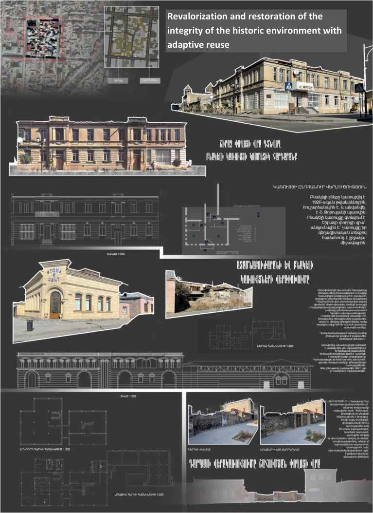
At the same time, an action plan has been put forward to implement the theoretical provisions in practical life, taking into account the needs of all stakeholders involved in each decision-making process and formatting a managing board involving as administrative members, also investors, specialists and population [8]. The example of the implementation of the theoretical provisions in practical life, meantime taking into account nowadays needs and trends, is presented in Fig. 1. A small part of Kumayri quarter with historic buildings in poor technical conditions and damaged urban environment has been transformed into a new attractive mixed-use district, keeping the urban identity and providing new functions to the historic buildings.
References
Cite This Article
TY  - CONF
AU  - Artyom Aloyan
AU  - Nune Petrosyan
AU  - Tatev Hayrapetian
PY  - 2023
DA  - 2023/01/10
TI  - Peculiarities of the Architectural-Spatial Environment Rehabilitation and Zoning of Gyumri City Historic Core
BT  - Proceedings of the 4th International Conference on Architecture: Heritage, Traditions and Innovations (AHTI 2022)
PB  - Athena Publishing
SP  - 287
EP  - 291
SN  - 2949-8937
UR  - https://doi.org/10.55060/s.atssh.221230.038
DO  - https://doi.org/10.55060/s.atssh.221230.038
ID  - Aloyan2023
ER  -


