
Email: designbyaspect@yahoo.uk.сom
Revised 22 January 2022
Accepted 7 December 2022
Available Online 10 January 2023
- DOI
- https://doi.org/10.55060/s.atssh.221230.041
- Keywords
- Urban planning structure
Historical settlement
Historical reconstruction
Core model
Historical boundaries
Principles of location of squares
City configuration - Abstract
This article contains the results of a study of the process of shaping the system of Turin squares in the period from 1565, when the city got the status of the Kingdom of Savoy capital, up to the current situation, within the territory of the historical core of the city. The research is carried out against the background of a historical and genetic analysis of the formation of parts and zones in accordance with their stages of evolution at different times (Roman camp, fortress-fortification, ‘commando zone’, burghs). The obtained data allowed us to present the historical and core model of the city and to trace back the genetic code of its development. The following was concluded: we reveal the principles of the location of squares, palaces and cathedrals, and their spatial relationships; variety of characteristics and parameters of areas, features of internal zoning; forms of organic reconstruction of a spontaneously formed urban structure from a medieval city to the representative ensembles of squares of the capital's appearance. The results of the study enrich the methodological basis of urban planning decisions while maintaining the historical status of cities.
- Copyright
- © 2022 The Authors. Published by Athena International Publishing B.V.
- Open Access
- This is an open access article distributed under the CC BY-NC 4.0 license (https://creativecommons.org/licenses/by-nc/4.0/).
1. INTRODUCTION
The theoretical foundations of urban planning activities in the context of knowledge of the formation of the urban planning structure of the capital cities of the world enrich our methodological basis for improving and maintaining the historical status of cities, their significance and potential. Turin is a unique example of a purposeful implementation of the method of transforming a city that originates from the Roman camp into a capital town with its own image [1]. It happened in stages, based on the method of reconstructing the urban structure to develop organically in line with regularities, relying on traditions and internal trends, and thanks to the skill of architects. The restructuring and alignment of the streets was carried out through careful observance of the existing parameters, ‘systematization’, streamlining, and tactful adjustment. The city-forming role of new palaces and public buildings was taken into account, and the orientation towards the main entrances and palaces was maintained.
The square, connected with the architecture of the palace or palazzo, appears as an integral element of reconstruction and development; it was the basis for setting accents. This is an element of the construction of the urban structure, a form of the urban planning organization for the sake of connecting new and old parts through growing up the structure, which we consider primarily at the level of the city, tracking its development as a single organism.
2. RESEARCH METHOD: SHAPING THE ENSEMBLES OF TURIN SQUARES AS A PROCESS
The town-planning structure is a historical-genetic model, in which parts of the city are clearly represented at different times [2].
Our method is based on the following principle: building a sequence of elements in strict accordance with the time of occurrence of each component of the structure. A graphic-analytical analysis is carried out, which includes: a) establishing the initial stage of the origin of a certain urban structure, as well as the role and initial location of this area; b) identification of the foundations of subsequent development; c) configuration of the boundaries of zones and the order of their relative position as the emergence and sequence of development of the territory; d) tracking of locations and formation of zones of localization of areas; e) generalization of large genetic parts and their mutual arrangement; f) identification of the principles of arrangement of ensembles; g) identification of the genetic model and code for the development of the urban structure.
For the purposes of systematization, let us imagine the initial array of objects under study in the following way: the central axis from the Palazzo Reale to Porto Nuovo, the western part of the considered territory of the historical center, and the eastern part. Field surveys are carried out with the analysis of urban planning characteristics and fixation of visual disclosures. We track the formation of dominants (churches, palazzi, certain complexes of constructions) based on the analysis of archival sources in the evolutionary context and making graphic fixation. A historical-genetic model and a code of development are being built.
Let us conditionally allocate zones of localization of zones of squares concentration. The north-south axis dominates in the form of the Central rod (A), Western part (B), Eastern part (C). The central rod (A), originating from the Caesar Augustus Square, passes to the neighboring San Giovanni. Further, the system goes along the dominant new axis to Piazzetta Reale, Piazza Reale, Castello, Carignano, San Carlo, C.L.N. and Piazza Carlo Felice, with neighboring Paleocapa (on the west) and Lagrange (on the east). Porto Nuova Railway Station serves as the southern end (Fig. 1).
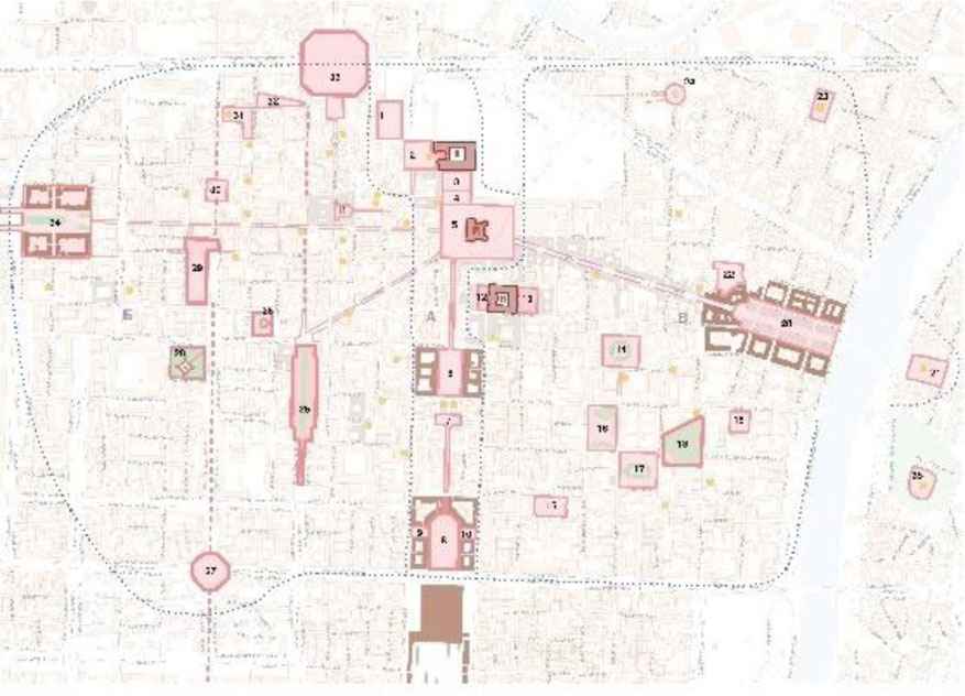
Scheme of distribution of the squares on the territory of the historical core of the city. A – Central rod; B – Western part; C – Eastern part. The palazzi (palaces) are highlighted in brown: R – Reale, M – Madama, K – Carignano. The squares are highlighted in red. The location of cathedrals, churches, monastic dominants are marked in yellow. Squares: 1 – Augustus Caesar; 2 – San Giovanni Battista 15th century; 3 – Piazzetta Reale; 4 – Reale; 5 – Castello; 6 – San Carlo; 7 – C..L.N; 8 – Carlo Felice; 9 – Paleocapa; 10 – Lagrange; 11 – Palazzo di Citta; 12 – Carignano; 13 – Carlo Alberto; 14 – Carlo Emanuele II; 15 – Bodoni; 16 – Valdo Fusi; 17 – Aiucola Balbo; 18 – Cavour gardens; 19 – Maria Theresa; 20 – Vittorio Veneto; 21 – Gran Madre di Dio; 22 – Piazzale Aldo Moro; 23 – St. Giulia; 24 – Largo Montebello; 25 – Solferino; 26 – Lamarmore gardens; 27 – Largo Vittorio Emanuelle II; 28 – Citadel; 29 – Arbarello; 30 – Savoy; 31 – Consolata; 32 – Emanuele Filiberto; 33 – Repubblica; 34 – Statuto; 35 – Monte de Cappuccino. Scheme by L.I. Kubetskaya and N.O. Kudryavtseva based on the map of Turin.
3. ARCHITECTURAL AND URBAN PLANNING ORGANIZATION: ANALYSIS OF LOCALIZATION AND PECULIARITIES
This article analyzes the system of squares on the territory, the boundaries of which are the highways in the west: Corso Castelfidargo, its continuation Corso Bolzano, following along the railway route. Corso Regina Margherita serves as a boundary to the north; the Po River outlines the territory from the east; and Corso Vittorio Emanuele II forms the southern border. Studying the localization of the squares and their distribution on the territory of the historical center reveal the process of historical evolution.
For Turin, a decisive factor that provided its originality and uniqueness was its elevation to the rank of the capital of the Kingdom of Savoy. Its construction was intensified when the Kingdom of Savoy chose it as the seat of the royal court of Savoy after giving it the capital status in 1563. The court moved from Chambéry to Turin [3]. The place for the new capital was not chosen by chance. As far back as pre-imperial Roman times, the location of Turin was defined by its important role as a hub located on the main passage of the Romans for their conquest and expansion through the Alps from south to north. The second circumstance indicated that in this place there was an ancient settlement of Menza Isiasa, which was of Egyptian origin. Thus, the ancient connection of the Savoy Dynasty with Egyptian roots was affirmed, which increased the degree of its nobility.
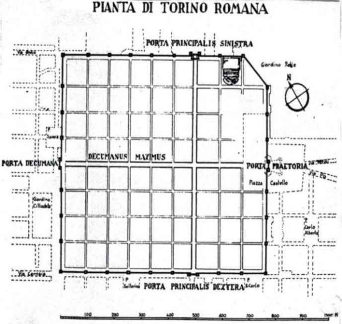
The first stage in the formation of the urban structure of Turin was the Roman camp that arose on the site of the preserved territory near the current Caesar Augustus Square in the 1st century BC (Fig. 2) [4]. It was to the east of the square, that the place of the residence of the royal Savoy court was chosen. In 1567, a fortification was erected. There was the Roman camp as an ancient beginning, and the plan of the 16th century with fortifications as its development (Fig. 3) ([4], pp. с.196).
On the plan of the 17th century, we see that the orientation of the planning of the decumanus and cardo of the Roman camp was preserved in the urban structure, but the north-south axis was shifted. A new Via Nuova arose, oriented towards the central façade of the Palazzo Reale, and the north-south axis was shifted eastward, since the street was already oriented towards the royal palace, Palazzo Reale. It was then that the main longitudinal axis south-north of the future central core was laid, connecting ten interconnected squares from Palazzo Reale to the future main railway Station Porto Nuova.
Plan of the Roman camp.
Displacement of the main lines of the 16th and 17th centuries in comparison with Torino-Romana ([4], pp. c.196, the cardo and decumanus). 1 – Via Nuova; 2 – Via Delle Patte; 3 – Via d’Italia; 4 – Palazzo de Citta; 5 – Via Delle Herbe; 6 – Porta Principale Sinistra, Porta Palatina; 7 – Piazza Castello; 8 – Via Po ([4], pp. c.216).
The very birth of the metropolitan system of the city squares is associated with the Palazzo Reale, in front of which the square of the same name arose. To the west of the palace there was already located the main city cathedral of San Giovanni with the square of the same name (Fig. 4). The cathedral was built in the 15th century in the Renaissance style according to the order of Cardinal Domenico Della Rovere, by design of Meo del Caprino [5]. It was chosen as the place of eternal storage of the main Christian shrine: the Shroud of Turin.
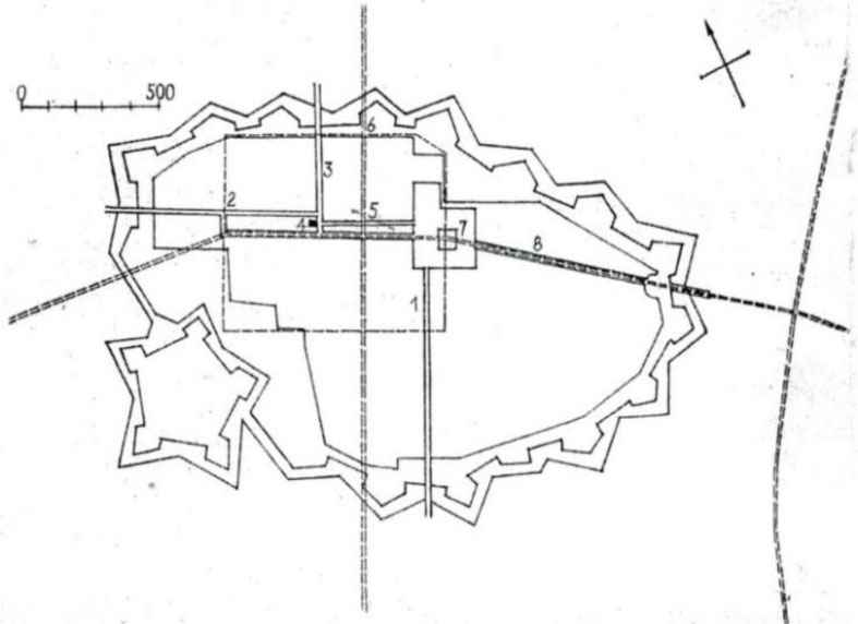
The royal residence became the core, to which a new edifice grew along the southern perimeter: the Palazzo Ciablese. Since 1642, the palazzo has become the residence of Maurizio of Savoy, formally Cardinal and Duke of Ciablese, the favorite son of Carlo Emanuele III. Later the palace became the residence of the cardinal, adjacent to the palazzo of members of the royal family. It led to an increase in the total area of the squares, primarily eastward and southward of the Porta Palatina to the Porta Principale Sinistra. At the same time, the territory of the palaces from Piazza Reale increased. It was the beginning of the emerging core of the royal and spiritual power of the zona di commando (Fig. 5) ([4], pp. c.220).
With the gradual shift of the command center to the extreme northeast of the city, the Piazza del Duomo (now San Giovani) was clearly separated from the Piazza Castello, and, by comparison, was extremely modest, even after the design of Carlo di Castellamonte made in 1622. To the south of the Palazzo Reale, the construction of a new palace of the Palazzo Madama for the royal family was started, which led to changes in the spatial system, the parameters of the squares of the main core.
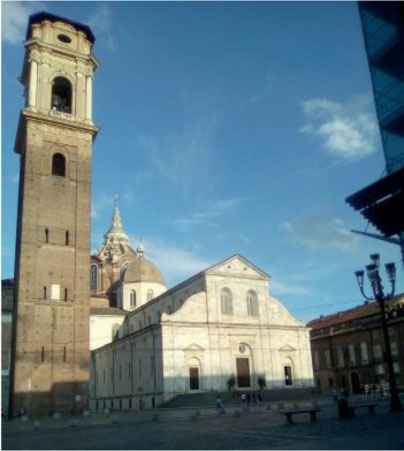
San Giovanni Cathedral. Architect: Meo del Caprino (15th century). Photo by the authors.
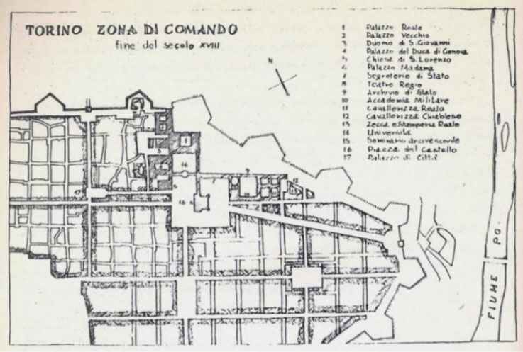
Plan of Turin at the end of the 1700s: headquarters of the Zona di Comando and main lines of the axis of development. 1 – Palazzo Reale; 2 – Old Palace (Palazzo Vecchio); 3 – Cathedral of San Giovanni; 4 – Palace of the Duke of Genoa Duca (Palazzo Ciablese); 5 – Church of San Lorenzo; 6 – Palazzo Madama; 7 – State Secretariat; 8 – Theatre Reggio; 9 – State Archive; 10 – Military Academy; 11 – The Corps of the Royal Cavalry; 12 – Ciablese Cavalry Corps; 13 – Mint and Royal Printing House; 14 – University; 15 – Archbishop's Seminary; 16 – Piazza di Castello; 17 – Palazzo di Chitta; 18 – Piazza San Carlo; 19 – Piazza Carlina (Square of Carlo Emanuele II) ([4], pp. c.220).
The existing former ancient castle of Acaja, expanded and restored in the mid-14th century, since 1420, has included in its volume two towers of the Roman Decuman gates of the Porta Pretoria, and other early medieval buildings. It became the New Palazzo, the home of the ‘royal ladies’, most notably the regent Christine of France (1606–1663), between 1638 and 1640. Subsequent participation in 1718–1721 of Filippo Juvarra in the urban restructuring of Turin led to the renovation and creation of the Baroque façade, representing the front of the ancient castle in the center of Piazza Castello. From Via Po, the palace is revealed in the form of a medieval Romanesque gate (Fig. 6A+6B). In the urban planning structure, Palazzo Madama has a town-forming significance (Fig. 6C).
The new palace also influenced at the space of Piazza Castello. It increased eastward to the square. The expansion of the royal and cardinal’s residence with the adjacent squares, having been continued for many years, served as basis for the formation of the zona di commando. As construction of the Palazzo Reale itself continued for many years, buildings for the archive and library were built from its western flank; a full-fledged perimeter of the square at the palace was formed; and Piazza San Giovanni became almost isolated. With the reconstruction and renovation of Palazzo Madama, the space of Piazza Castello responded to the architectural merit of the new façade, which increased its dominant role [6]. The space of Piazza Castello became the main planning focus of the center. In front of the royal palace (Palazzo Reale), the space of the square was shaped, and Piazza Reale was formed. The spatial system of the core is dominated by the two cathedrals of San Giovanni and San Lorenzo, which are actively present in the field of view from Palazzo Madama (Fig. 6D).
On the plan of 1751, two more significant squares are seen: to the south it is the nearest to Castello San Carlo square, and to the east there is Carlin square (later the square was called after Carlo Emanuele II).
There are noticeable differences in the spatial and urban planning characteristics of the three zones of the historical core identified by us: the central core A, the Western part B, and the Eastern part C (see Fig. 1).
In the western part of the territory, spiritual origins in the development of space were of a paramount importance. The streets were named after saints associated with local early churches of San Domenico, San Agustino, Consolata, Santa Chiara (on Via Orfane Bernardo Antonio). To the south there is Piazza Visitazione. Their planning and visual interrelation turns them into a kind of urban texture with a high concentration of cathedrals. One cluster is located near the Cathedral of San Giovanni to the sanctuary of Consolata; there are eight churches in it. There are at least 24 churches within the western side of the historical center.
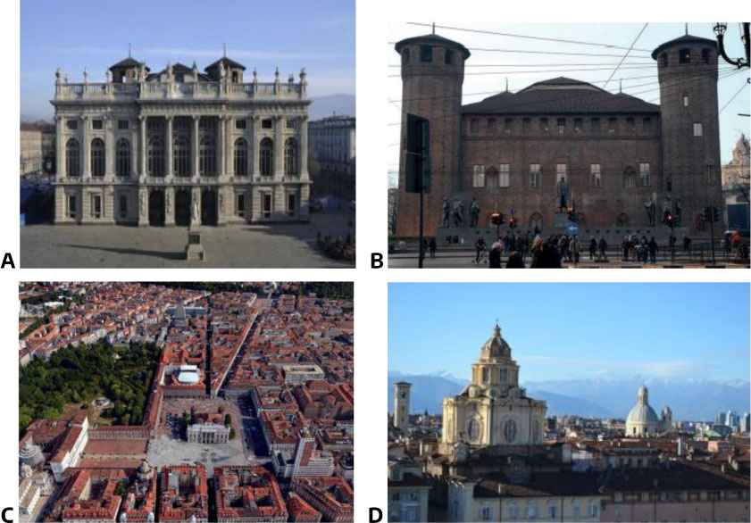
Turin: Palazzo Madama. A – Western façade looking at the Piazza Castello and Via Garibaldi (architect: Filippo Juvarra); B – Eastern façade in the form of the entrance gate of the Porta Pretoria; C – The city-forming role of the Palazzo Madama in the structure of Turin; D – Panorama of Turin as seen from the east from Palazzo Madama (in the foreground is the Church of San Lorenzo; to the north is the Cathedral of San Giovanni Battista). Photos from open sources on the internet.
In the eastern part of the historical center, the distribution of squares has its own characteristics and its own compositional system. The matrix distribution of squares is more obvious, from the central rod, especially near Piazza Castello and San Carlo, and there is a movement from the center towards Po [7]. At the same time, the concentration and proximity of squares near the main axis are noticeable.
In the north of the eastern part of the historical core, the system of squares develops in the form of the main middle link: Piazza Carignano, Carlo Alberto, and Vittorio Emanuele II, where splendor and representativeness prevail. To the south, near the central core (piazza Bodone), a chain of squares ‘sags’, attaching a chain of piazzas: Valdo Fusi (sports and training ground), Balbo gardens, Cavour gardens, then Maria Theresa. In their location, a latitudinal direction is noticeable, it forms a matrix distribution of squares, from the central Castello and San Carlo to the east and reflecting the movement from the center towards the Po River.
Piazza Vittorio Veneto completes the system of squares in the east, facing the church of Gran Madre di Dio, the main shrine located on the opposite bank of the Po River (Chiesa Parrochiale Della Gran Madre di Dio). The front northeastern part of Vittorio Veneto Square looks at a six-column portico with a powerful dome. A monument to Vittorio Emanuele II rises along the central axis of the square in front of the church building. Piazza Vittorio Veneto together with the Cathedral of Gran Madre di Dio create a single large-scale space and urban ensemble facing the city (Fig. 7A). Piazza Vittorio Veneto is one of the most actively functioning and visited area. Thanks to it, the compositional connection of Castello Square with the main cathedral (Gran Madre di Dio) is provided (Fig. 7B) [8]. Its role is important as a pre-bridge and in transport services.
Piazza Carignano actually belongs to the main axis system. In terms of architectural and artistic perfection, Palazzo Carignano plays a dominant role, not in terms of height, but in terms of monumentality of forms, the parameters of an outstanding palace ensemble that occupies a quarter with the square of the same name in front of the palace. The architectural solution was embodied according to the project by Guarino Guarini in 1679–1683; the palace was built for Prince Emanuele Filiberto of Savoy. The architecture of the building reminds of Bernini's work in the Louvre (1664) (Fig. 7C) [9].
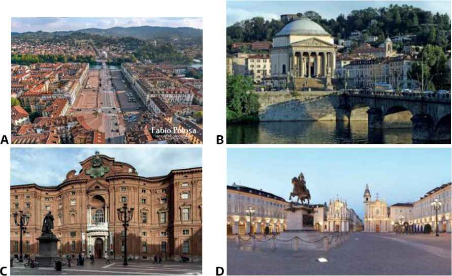
Turin: Piazza Vittorio Veneto. A – View from the south, ending with the Gran Madre di Dio; B – View of the Cathedral of Gran Madre di Dio from Piazza Vittorio Veneto; C – Palazzo Carignano, view from the square with the same name (architect: Guarino Guarini, 1679–1683, source: [9]); D – Piazza San Carlo, view from the north (source: [10)].
In the location of the squares, the proximity and even the adjacent position of the borders are revealed, and the square turns into a core consisting of several squares (Piazza Reale and San Giovanni, Piazza Castello). The central core dominated by Piazza San Carlo e Carignano and Porta Nuovo has 10 squares together with its neighbors; the Eastern and Western zones each contain about 15 squares.
An analysis of the evolution of the formation of the squares of Turin showed that (especially in the western part) the spiritual dominants were built earlier than the squares themselves. The Palazzo was oriented by the main planning axis of the urban structure: from the Palazzo Reale to the Porta Nuova along Via Roma, from Palazzo Madama to the east up to the church of Gran Madre di Dio along Via Po, to the west Dora Grossa (Giuseppe Garibaldi). The squares also served as closing elements in the city landscape.
The distribution of the squares on the territory of the western and eastern parts took place in accordance with their own principles, caused by urban planning specifics. In the western part, the system is built in the form of two south-north meridians. The first is Largo Vittorio Emanuele II – Piazza Arbarello and Consolata; second is Piazza Solferino – Piazza Della Repubblica.
In the eastern part, the distribution follows the matrix principle, the character of the areas is representative in the capital. These are Carignano, Carlo Alberto, Carlo Emanuele II, Bodone. They are the main cultural institutions, the Egyptian and Risorgimento museums, the National Library, the Philharmonic. Piazza Cavour with the Balbo Gardens introduces a free configuration in localization, providing a diagonal connection between important nodes between Porta Nuova and Piazza Felice with Piazza Vittorio Veneto.
The most famous is Piazza San Carlo [10]. It occupies a dominant position on the central rod. Its length is 168m and its width is 76m. From the north and south it is flanked with latitudinal transport streets, leaving the inner space for pedestrians. This square is part of the main longitudinal street: Via Roma. Until 1563, it was not included in the boundaries of the city and arose when the territory of the city was expanded in 1617 according to the project by outstanding architect Carlo Castellamonte. It was opened for visitors in 1638. The forum square was originally called Piazza Reale. In 1650, military parades were hold there, and the square changed its name to Piazza d'Armi. In 1750, parades were transferred to Piazza Vittorio, and since then Piazza d'Armi has been called Piazza San Carlo. The splendor and pomposity are emphasized with the continuous front of the three-story baroque buildings surrounding the square along the eastern and western borders with arched galleries (122 such elements on each side) and the monument to Emanuele Filiberto. In 1764, the architect Benedetto Alfieri reconstructed the square, after which it acquired its current elegant appearance. The entrance to the Piazza San Carlo was narrowed; and it created a contrast that enhances the vast expanse of the dominant square, since the C.N.L. (Fig. 7D).
On the southern perimeter, the entrance is symmetrically flanked with twin churches: San Carlo (with a campanile on the east side, 1619) and Santa Cristina (from the west side, 1639).
Piazza San Carlo still retains the title and functions of the main square and its special architectural representativeness created by the skill of eminent architects. On all sides, it is surrounded with palazzi, among which there are residences of aristocrats of the 17th–18th century.
An analysis of the relative position of the parts in the process of their shaping made it possible to identify the code for the development of the urban structure in the form of a spiral moving counterclockwise. It could be traced in the lattice type of the planning structure. The code does not depend on the type of planning structure, but on the order of the relative interpositions of the parts. This is confirmed with the information shown in the following illustration. The system of squares is the organizing compositional basis of the urban planning structure, which ensures the unity of the city center. And it contributes to the fact that the historical core of Turin is considered as ‘the city as a whole’, a single object of protection, which is a monument of urban planning (Fig. 7).
As revealed by graphic-analytical methods, the city grew in parts. These genetic parts are clearly visible in Fig. 8 ([4], pp. c.200).
From the second half of 1564 until the end of 1715, Turin was expanded three times. Initially, a citadel was added to the territory of the former Roman camp (Fig. 8 top). The first expansion of the palace space was already noticeable by 1620; it extended southward between the Citadel and the slope to the Po River, on a flat area closer to the Piazza Castello (Fig. 8 center top). The second extension took place of the territory of the palace core by 1673; it was in the east, in the area adjacent to Piazza Castello, making it more central in comparison with the surrounding area. The third extension of the royal nucleus was realized by 1685, and the fourth by 1715; they were made westward, between the Citadel and the escarpment towards the Dora, the only “iti piano” area still adjoining the Old City. The three extensions also adopted an orthogonal grid and orientation similar to the Old City.
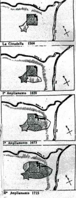
Scheme of the urban development of Turin presented in a sequence of shaping parts created in different times. Top – 1564; Center top – 1620; Center bottom – 1673; Bottom – 1715 (source: [4], pp. c.200]).
4. CONCLUSION
The graphic-analytical method of comparing the boundaries of the growth of the city territory on the base of the surviving drawings revealed the patterns of the spatial development of the city; that is obvious from Fig. 8. An analysis of the relative position of the parts in the process of their formation showed that the build-up took place in a counterclockwise spiral embedded in the original structure.
The code was not directly dependent on the type of urban planning structure, but it could be found in the trajectory of building up new parts and in the order of the relative positions of those parts. It is confirmed with the information shown in the illustration.
The given research results prove that in predicting the development strategy of a city, it is necessary to carry out a historical and genetic analysis of the process (sequence) of its formation, revealing a model of its structure. This will allow to take into account the objective patterns of development of the urban structure. A model of reconstructed ancient zones has been built and new patterns of development of later zones and quarters have been identified and presented the relationship between the sequence of the territorial development of the city of Turin and the reflection of it in the formation of new areas.
Using the example of Turin, we have shown that the creation of a square is a form of planning organization of a site for joining a new territory to a historical one, for continuity in development of an urban structure. In the distribution and localization of areas identified by the authors, the following are established: dominance of the central axial rod; in the western part, according to the location of the areas, there are tendencies of spatial orientation in longitudinal south-north orientation; in the eastern part of the latitudinal movement from the central cluster to Piazza Vittorio Veneto and Gran Madre di Dio.
Arising in the outskirts, spontaneously used territories, the squares became a form of planning organization in joining a new part to the old one. Thus, unity and stylistic consonance were ensured in the urban planning structure. So, Piazza Vittorio Veneto and Statuto are formed by neo-classical blocks typical for Turin. Piazza Repubblica was also a significant node. The entire historical center of Turin appears as a single ensemble.
AUTHORS' CONTRIBUTION
Lyubov Kubetskaia studied the works of Amedeo Castellomonte, analyzing the stages and nature of the reconstruction and formation of the areas of Turin in accordance with the temporal stages, established the relationship between the sequence of the territorial growth of the city of Turin and the genetic code of its development. Tracing the shaping of later transformations of the squares and the creation of new ones (San Carlo, Solferino), Natalia Kudryavtseva revealed the role of the squares as a form of joining new parts of the city to its historical core; she discovered the peculiarities of the location of cathedrals in relation to the squares and the principles of localization of the squares in the western and eastern parts of the historical center.
REFERENCES
Cite This Article
TY  - CONF
AU  - Lyubov Kubetskaya
AU  - Natalia Kudryavtseva
PY  - 2023
DA  - 2023/01/10
TI  - Ensembles of Turin Squares and the Urban Planning Code of City Development
BT  - Proceedings of the 4th International Conference on Architecture: Heritage, Traditions and Innovations (AHTI 2022)
PB  - Athena Publishing
SP  - 307
EP  - 315
SN  - 2949-8937
UR  - https://doi.org/10.55060/s.atssh.221230.041
DO  - https://doi.org/10.55060/s.atssh.221230.041
ID  - Kubetskaya2023
ER  -


